Grant-in-Aid for Transformative Research on Area (B) "Micro-meteorology control" Project (representative : Ryo ONISHI)
We are working on the development of technologies that integrate simulation and data science, with the aim of bringing about major changes in society through the realization of Micro-meteorology prediction.
In this project, we envision the realization of a future city where autonomous drones and other systems provide a variety of services in response to the ever-changing environment. In such a future city, not only these autonomous systems will be provided with micro-meteorology prediction information (detailed weather near the surface of the earth, which is strongly influenced by human-made structures and human activities), but also the large amount of sensor information acquired by the autonomous systems will be used for prediction. This bi-directionality enables the fusion of real and cyber meteorology. In order to realize this fusion, our research group aims to develop a harmonic prediction simulation technology that is adaptable to the ever-changing society and environment, and also has real-time capability. Specifically, we use a original distributed multi-scale data assimilation method to integrate not only a large amount of environmental sensor information from ultra-high-density observations, but also socioeconomic information such as anthropogenic heat emissions into simulations, thereby realizing adaptive prediction. Furthermore, we aim to realize a real-time micrometeorological prediction system that can generate prediction information at ultra-high speed by integrating AI technology and prediction simulation technology.
For more information, please refer to this page
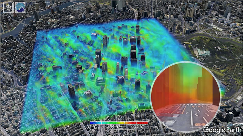
This shows the three-dimensional distribution of temperature around Tokyo Station.
A related video is now on permanent display as "Tokyo Heat Island" at Miraikan, National Museum of Emerging Science and Innovation.
Fig.2 : "Future Applications of Micro-meteorology Simulations." — DLab Future Techscapers (DLab (Japanese))
Digital twin project for ultra-high definition weather (joint research with NTT)
By combining ultra-high-definition weather forecasting technology and digital twin computing technology, we aim to create ultra-high-definition weather information and also to make new use of it.
In order to realize a digital twin for weather, which is the natural environment surrounding human beings, we are developing a fusion of state-of-the-art ultra-high definition weather forecasting technology and digital twin computing technology If this is realized, it is expected that ultra-high definition weather information on a micrometeorological scale will be created and a new utilization infrastructure will be established.
Lagrangian Cloud Simulator (LCS) Project
We are developing sophisticated large-scale simulation technology to develop a simulation method that captures the microphysics of each cloud particle.
Torrential rains cause a lot of damage around the world every year. If we can predict their occurrence, we will be much closer to realizing a safe and secure future society. For this purpose, it is essential to improve the accuracy of weather prediction models. But is that enough? At what level is it possible to predict heavy rainfall? Is it possible to predict the time of occurrence to ±1 minute and the center of occurrence to ±100 meters? Unfortunately, current weather prediction models have too many empirical parameters to reveal the intrinsic predictability of a given heavy rainfall event. However, in order to provide prediction information that can be used even for mandatory evacuation, it is necessary to provide reliability information (the possibility of being wrong) of the prediction at the same time, which comprehensively considers the accuracy of the prediction simulation and the intrinsic predictability of the event. Otherwise, no matter how detailed the forecast information is, it will be "The Boy Who Cried Wolf". In this project, we are developing a cloud simulation method that eliminates empirical parameters as much as possible by using the Lagrangian tracking method to precisely track the physics of each cloud particle (Onishi et al. 2012; Onishi et al., 2015; Kunishima & Onishi, 2018).
Tracked the movement and growth of all aerosol particles, and reproduced for the first time in the world a series of processes from the formation of tiny water droplets to their growth to raindrops and arrival at the ground surface as precipitation particles.(Kunishima & Onishi, Atmos. Chem. Phys., 2018)
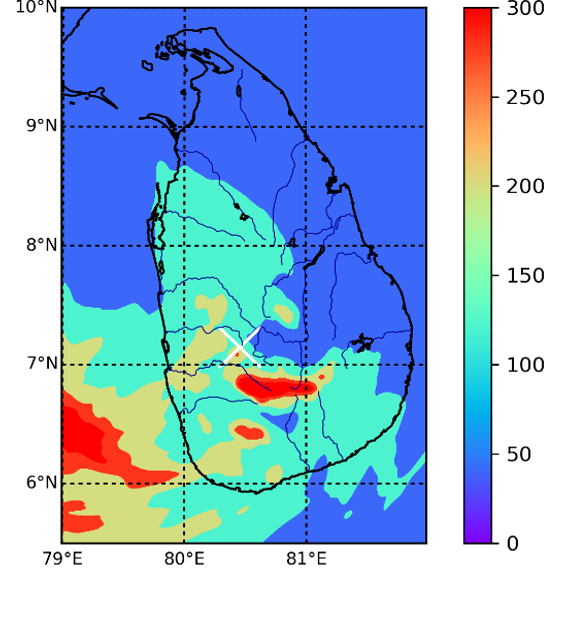
SATREPS "Development of Early Warning Technology for Rainfall-Induced High-Speed Long-Distance Landslide Disasters in Sri Lanka" Project
We are working on the development of technologies that integrate simulation and data science with the aim of realizing a safe society through the realization of highly accurate prediction of slope rainfall.
In this project, we are developing a slope rainfall prediction technology using MSSG (Multi-Scale Simulator for the Geoenvironment), a multi-scale atmosphere-ocean coupled model being developed mainly by Tokyo Tech/JAMSTEC. So far, we have implemented the latest cloud microphysics parameterization (Seifert & Onishi, 2016) that can take into account the effect of atmospheric turbulence in MSSG. Rainfall prediction simulations using the latest cloud microphysics parameterization were applied to the cases of May 15, 2016 and May 23, 2017, which brought heavy rainfall to Aranayake, Sri Lanka. As a result of comparing the numerical prediction with the rainfall data provided by NBRO (Ministry of Land, Infrastructure, Transport and Tourism, Sri Lanka), it was found that the numerical prediction can reproduce heavy rainfall and that the slope rainfall can be increased by considering the effect of atmospheric turbulence. We are currently working on the development of a super-resolver that can up-convert (super-resolve) rainfall prediction with a horizontal resolution of 2 km to high-resolution prediction with a horizontal resolution of 500 m, using rainfall maps obtained from high-resolution (500 m resolution) simulations as training data. Once this is developed, it will be possible to build a local implementation system that can issue real-time early warning information for landslides for individual slopes in Sri Lanka at a low cost. It is expected that the developed rainfall forecasting technology will be deployed worldwide
For more information, please refer to this page.